Making it up as they go along
The Corps gives updates on the outfall canal remediation projects (those are the projects to raise the Safe Water Elevation, or SWE, along all three outfall canals to 8 feet) every month to the Southeast Louisiana Flood Protection Authority - East (SLFPA-E). SLFPA-E has been good enough to upload the slides from those presentations to their website. Here's links for the ones I've seen thus far:
late March, 2011 (at end of report)
late April, 2011
early June, 2011
The June update includes this information on the 17th Street project:
When I first read that, I thought it was good, because I had remembered there was a sub-8 foot SWE reach along the 17th Street canal that wasn't included in the original remediation plans. Then I went back and looked and realized it was actually Reach 30:

So where is Reach 16?
It's across the canal from Reach 30, down south of the I-10 bridges:

The Corps included pictures of it in the presentation:


Reach 16 was not included in the 17th Street canal remediation project when the contract was awarded in December, 2010. But now the Corps is saying extra dirt might be required at the toe of the levee (the part of the levee at its bottom where it goes from sloped to flat), and is even including pictures of the Reach 16 toe.
The changing Safe Water Elevation of Reach 16
So what's going on with Reach 16? The main chart of Safe Water Elevations on page 12 of the October, 2010 17th Street SWE report (report and all appendices here) shows the Safe Water Elevation for Reach 16 was the bare minimum of 8 feet, meaning no remediation was required:


So if the SWE was 8 feet, based on seepage considerations, what's the problem?
A clue comes from further inside the report. These types of reports are written from the inside out, with the individual results sections compiled first, and then the introductory and conclusory sections written around them. Those "outer" sections are the ones written last and which have the heaviest attention paid to them during editing, because they are the sections most likely to be read (who except crazies like me reads the whole report?).
So when one reads the introductory and conclusory sections, one finds this unambiguous statement reinforcing the main chart:
But when we look at the individual section on the seepage results, we find this chart on page 124:


The actual calculations originally resulted in a seepage SWE of 7.5 feet, 6 inches below the 8 foot target. A SWE of 7.5 feet may have meant more remediation along the canal (theoretically, though we've seen the Corps ignore other sub-8-foot calculations). Reach 16 is 1615 feet long, so that's a lot of remediation.
So how did the SWE jump from an unacceptable value of 7.5 feet to the barely acceptable value of 8 feet? The report itself provides the rather bizarre answer, but first there's a brief detour to explain (in my rudimentary understanding) how seepage works.
The (very) basics of seepage
To help, here's a diagram of the layers of various soil along Reach 16:

This diagram is taken from the calculations for "slope stability," not seepage. The diagram for seepage doesn't include such clear delineations of the different soil types, so I grabbed this one.
As you can see, there's a thick layer of sand - shown in green - underlying the whole thing. I've noted that the bottom of the canal is at -9.4 feet, while the sand starts at -9 feet.
On the "protected" side - i.e. the non-canal side in Jefferson Parish - there's stronger, less permeable soil overlying this sand, both within the levee and next to it. That's the stuff shown in yellow and orange, labeled either "Marsh," "Embankment Fill," or simply "Fill." Below the sand is a layer of pretty impermeable clay, shown in red and brown. And at the top of the diagram is the I-wall, which penetrates down to -1.5 feet, or 7.5 feet short of the top of the sand layer and 44.5 feet short of the clay layer.
For seepage to occur, water from the canal must contact the sand surface directly. It must then travel through the sand to the protected side. For it to truly be a problem, though, it must exert an upward force against the protected-side soils which is greater than the force exerted downward by the weight of those soils. If it does this, then a connection like a pipe is made between the canal and the land side, and the foundation underneath the levee and floodwall can be quickly undermined.
In Reach 16's case, it would seem the first part of a potential seepage problem - a canal bottom lower than the top of the sand - is in place. The bottom of the canal is 0.4 feet into the sand layer. This condition is referred to by the Corps' consultants as an "open bottom," and Reach 16 is not the only reach along the 17th Street canal to exhibit it. Indeed, Black & Veatch analyzed five other reaches with survey data indicating an open bottom: 15 (later split into 15A and 15B), 31, 32, and 33. All these are reaches near the I-10 or Veterans bridges:

These calculations, while quite complicated in their guts, are simple in concept. The canal is modeled from known survey data. Water is placed in the canal up to the target SWE of +8 feet and to a maximum of +10 feet (the Corps limited SWE calculations to 10 feet of water, even though the walls are much higher). If the resultant calculated safety factor is above the prescribed safety factor for the particular type of failure under study (global stability, slope stability, gap, seepage, etc, each of which has its own safety factor), then the reach under consideration passes.
In the case of all those other "open bottom" reaches, Black & Veatch was able to load the canal up with water to an elevation of +10 feet and not fall below the Corps' seepage safety factor of 1.6.
But for Reach 16, Black & Veatch could only load the canal up with water to an elevation of +7.5 feet before they fell below the 1.6 safety factor. Just for reference's sake, the canal was able to be loaded up to +10 feet on Reach 16 for all the other types of failures Black & Veatch was looking at. So seepage was what is called the "controlling" criterion for Reach 16.
Sediment
Now, there's one other thing that can mitigate against seepage. That is stopping the canal water from getting to the sand in the first place. All three outfall canals have sediment along their bottoms, carried there from the city's streets and drainage tunnels and pipes. It is deposited there constantly, and especially when there's a rainstorm and water is pumped along the canals out to the lake.
I wrote about this sediment in 2009, when I based an entry on the 2007 iteration of the 17th Street SWE report. That report indicated sediment was quite thick along the entire canal. However, those thickness readings were based on soundings, not direct borings into the canal bottom. In addition, the 2007 report did not characterize the sediment at all, including its permeability or how much of it was mixed in with sand. The October, 2010 report notes (and this is quite important) that the Corps has still not measured the sediment, referred to as "fine grained materials:"
This is a yawning gap in the data required to completely analyze seepage.
As noted above, a number of reaches were analyzed as "open bottom" reaches. With regard to sediment, that likely means that Black & Veatch and the Corps made a judgement that the sediment blanket along those stretches was too thin to stop the water flowing through the direct connection exposed by the top of the sand layer being above the bottom of the canal. In addition, Black & Veatch also noted six other reaches - 14, 17, 18, 29, 30, and 34 - which had thin sediment layers, but whose canal bottoms were apparently not below the top of the sand layer. These weren't analyzed as open bottom reaches.
So they were making judgements about the thickness of the sediment layer throughout the preparation of the report. But how did they do so when they had no detailed canal borings to confirm those thicknesses? Where was the hard data?
Detailed borings of the sediment along the London Avenue canal bottom in 2010 led to a radical recasting of SWE calculations there, essentially restarting the engineering effort and eventually leading to the inclusion of many reaches in the remediation project along that canal which had previously been thought safe. Yet, no similar effort was undertaken along the 17th Street canal (or the Orleans Avenue canal for that matter).
So with no detailed information on the sediment overlying the beach sand at the bottom of the canal along Reach 16, and with a calculation showing a sub-8-foot SWE along that reach from seepage due to an open bottom, how then did the SWE jump 6 inches to 8 feet? What was that judgement based upon?
1983
This is where it gets bizarre.
Instead of either:
a) using the lack of detailed sediment data to take the conservative course - assuming an open bottom along Reach 16 and sticking with with the 7.5 foot SWE within the seepage section of the report, or
b) revealing the source of their heretofore undisclosed sediment thickness data,
Black & Veatch and the Corps chose a third course. They startlingly reached back almost 30 years to rebut their own seepage calculation. The report starts describing a December, 1983 test along the 17th Street canal's Reach 16 to determine whether a direct sand connection existed at the canal bottom. This test took place ahead of 1984-85 dredging of the canal by the Sewerage & Water Board, before the later walls were designed and built. The test was used to help get a permit from the Corps for that dredging. Presumably, reassuring the Corps that the canal would not be undermined by seepage during the dredging would go a long way toward getting the dredging permit. Since the dredging happened, it clearly did the trick.
In fact, seven years later, as part of the now-discredited 1990 17th Street canal design document which led to the placement of the I-walls destined to fail in 2005, the Corps themselves used the report of this test in the same way: to rebut concerns about seepage. Thus, it is beyond surprising to see it resurrected here to do the same thing a third time - rebut concerns about seepage - as if nothing had happened in the intervening decades.
Nonetheless, two whole pages of the 2010 report are devoted to blithely describing the 1983 test, recommended by Eustis Engineering to the then-consulting engineers on the dredging, Modjeski & Masters (Eustis still does millions of dollars of geotechnical work for the New Orleans District). The complete report on the 1983 test can be found within volume 2 of the 1990 Design Memorandum 20 (or DM-20), the base design document for the 17th Street canal walls. Scroll to page 78.
In 1983, at Eustis' recommendation, a 100' by 100' square area in the middle of the canal was excavated to expose the beach sand. Also, at Eustis' recommendation, piezometers were installed on the land side of the Reach 16 levee, just south of I-10. These piezometers sensed the water elevation in the soil below. If there were a seepage connection between the water in the canal and the piezometers outside the canal, changes in the canal water elevation would be reflected in the piezometer readings. Similar arrangements were a part of the 2007 London Avenue canal load test.
According to the 2010 report, during the 1983 test the water in the canal went up 0.41 feet while the sand was exposed on December 16, 1983, but the piezometers outside the canal either went down or remained unchanged. The 1983 test authors also noted that the test location was partially covered in sediment on the 16th, and that the entire location was covered in sediment three days later. To Eustis, this demonstrated that there was no seepage connection, either from the sediment cover or because there just wasn't one. Frankly, their reasoning is quite muddled.
However, Black & Veatch accepted the "no seepage" finding of the 1983 test, while including a token suggestion that before the SWE for Reach 16 is finalized, "a sampling program be performed to determine whether a [sediment] blanket exists at this location." But nowhere in the 2010 report does it indicate such a sampling program took place before the SWE for Reach 16 was raised to 8 feet in that same report. Indeed, there was no such sampling program during the 1983 test either. It appears that the 8 foot number came about directly - and only - as a result of Black & Veatch and the Corps accepting the findings of the 1983 test as gospel. It's like they just willed it into being. This is supported by the footnote on the master SWE chart on page 12 of the report:
...as well as the plain text of the 8 foot SWE in the main chart itself. This was stunning for me to read - a consultant in 2010, using the Corps' incomplete, muddled pre-Katrina design data to support a conclusion not supported by the post-Katrina data record, a data record also lacking key pieces of information. It's almost like they were looking for any shred of evidence that might support their pre-made conclusion that seepage could not possibly be a problem, their own calculations be damned.
I was not the only one to notice this.
Behind the scenes
On a consultant-written report such as this one, after the report is drafted it is sent to lots of people outside and inside the Corps for comments. They use a system called "Dr Checks" to log those comments, the responses, and the responses to the responses. Thus, the Dr Checks printout is the sort of document the public almost never sees - the official record of the internal engineering debates that go into the formation of these reports.
When I got the October, 2010 17th Street and Orleans Avenue reports, I was stunned to find the Dr Checks printouts were included as appendices (the London Avenue report didn't have one). The Orleans Avenue one runs 159 pages (complete Orleans Avenue report and appendices here). The 17th Street one is significantly shorter - just 25 pages long.
That doesn't mean the 17th Street Dr Checks printout is any less valuable. In fact it contains a brief but vigorous debate over seepage along Reach 16.
Keep in mind the Dr Checks comments are based upon draft versions of the report which we don't have. Thus, sometimes the comments mention a criticism which - when one reads the final report - it is clear eventually got addressed. Nonetheless, this particular chain of comments is extremely enlightening.
The comment chain starts with Noah Vroman, a Corps seepage expert working at the Corps' Engineer Research & Development Center (ERDC) in Vicksburg, Mississippi. Vroman's name has popped up often in the past few years in the many reports generated on seepage concerns along the London Avenue canal.
On July 23, 2010, Vroman says of Reach 16,
He is noting this because the acceptable seepage safety factor is 1.6.
Black & Veatch geotechnical engineer John Koontz is the first to reply to Vroman, on August 7th:
As noted earlier, the "toe" is the section of the levee at the bottom, where it goes from sloped to flat. It is generally the most vulnerable section, because there's less soil there than at the top.
Also as noted above, "DM-20" is the 17th Street Design Memorandum, or the official design document underpinning the floodwalls and levees which failed in 2005.
As to the substance of Koontz's comment, we can surmise that the description of the 1983 test had not been included in the draft version Vroman was reviewing in July.
Vroman responded on September 23rd with one of the longest Dr Checks comments I've seen in these documents. From the date and the context of the comment, I surmise this September 23rd comment is based upon a subsequent draft, which we don't have. Note that I've added paragraph breaks to Vroman's comment to make it more readable:
Let me pause here and point out that additional monitoring was conducted during that dredging. Piezometers were installed outside the canal as the dredging advanced along the canal between December, 1984 and April, 1985. They didn't really show any evidence of seepage. However, there was no characterization of the canal bottom as part of that monitoring.
Returning to Vroman's comment:
Based on the final text of the 2010 report, it appears this information was not in the September draft, but was included in the final report as a result of this comment.
Vroman continues:
And there it is - the critical question. Essentially, "what hard data do we have on the sediment?" And he's not asking for what was known in 1983 about a 100' by 100' section, but what is known along the entire canal - today. As was demonstrated on the London Avenue SWE effort, complete characterization of the sediment is unbelievably critical to understanding seepage. Since there has not been any comprehensive effort to do so along the 17th Street canal, it is only conservative to stick with the results from the "open bottom" calculations, which gave the 7.5 foot SWE for Reach 16. And, more importantly, the lack of that current, comprehensive sediment data brings into question how correct the seepage calculations are for the entire canal.
Vroman didn't just bring this up on the 17th Street report. We find him asking the same questions about sediment (also called "silt") on the Orleans Avenue report, because - like along the 17th Street canal - there was no comprehensive characterization of canal sediment at Orleans either. From a comment on the Orleans Avenue Dr Checks printout marked "this item flagged as a critical issue:"
Vroman's comments on the Orleans Avenue report appear to have won the day, as his concerns about seepage led to the seepage calculations getting redone to include consideration of an "open bottom" on Reach 1 and other places. And on Reach 1, seepage was found to be to be the controlling criterion. In fact, sheet pile is being driven there to completely cut off the seepage path as part of the Orleans Avenue remediation project, as shown in this photo from the June update:

Of course, without a comprehensive characterization of the sediment along the Orleans Avenue canal, doubt remains about many of the other seepage calculations.
The outcome on the 17th Street canal report was quite different. The Black & Veatch SWE project manager, Larry Almaleh, responded to Vroman's 17th Street comment on October 1, 2010, just before - or perhaps the day of - the report's final issuance:
Nowhere in the report is a precise identification of "significant sedimentation" outside of the 1983 test actually named or described.
But most telling is that the Corps ("HPO" is the Corps' Hurricane Protection Office, co-located with the New Orleans District) had apparently told Black & Veatch the result of the seepage calculations before they were done: "B&V has been told there is no seepage concerns in the 17th street canal by the HPO..."
I thought Black & Veatch was supposed to be reporting to the Corps on seepage concerns, not the other way around?
Handwaiving
So stepping back from all this, it looks to me like there was a ton of handwaiving going on around the seepage concerns at the 17th Street canal's Reach 16 specifically, and along the entire 17th Street canal generally, possibly on orders from the Corps Hurricane Protection Office in New Orleans. And while Vroman's comments apparently got an expanded description of the 1983 test added to the final report, it didn't change the underlying fact that Black & Veatch and the Corps were solely relying on a nearly 30-year-old test from a discredited document to support their pre-reached conclusion that seepage was nothing to worry about along the 17th Street canal.
So not surprisingly, despite calculations and the Corps' own non-New Orleans-based experts pointing to the absolute need to fully characterize the depth and composition of the sediment along the canal bottom, not to mention possibly remediate the 1615 feet of Reach 16 because of seepage, Black & Veatch issued their report in October, 2010 with the conclusive statement,
That conclusion then flowed directly into the scope of the remediation project along the 17th Street canal. Until this most recent project update nine months after the SWE report was issued and seven months after the remediation contract was signed, there has been no effort to address seepage along the canal, including at Reach 16. All the remediation efforts are geared to other concerns like overall stability.
The way the Corps and Black & Veatch got to that outcome - even if they are possibly correcting it now - should make people very queasy. How could anyone in good conscience use nearly 30-year-old incomplete 17th Street design data and ignore post-Katrina data collection and calculations to support conclusions about the canal's safety in the present day? After all that has transpired, and after all the Corps' pronouncements that they've changed, it looks like more of the same over five years later.
Reach 16 to be fixed anyway?
That brings us full circle to the June remediation project update, which mentions that the Corps is now looking at putting 6 to 18 inches of dirt at the toe of the levee along Reach 16, based on surveys of the reach. That toe is undoubtedly the point found vulnerable in the Black & Veatch seepage calculation that found the 7.5 foot SWE. Thus, if more soil is piled over it, presumably water carried through the sand by seepage would not be able to push up and cause a failure.
Of course, the only definitive solution to stopping seepage is not piling more dirt on the landside, but driving of 60 foot steel sheet piling into the clay layer along the entire reach. In fact, that has been how seepage has been controlled everywhere else, including on both the Orleans Avenue and London Avenue remediation projects. I assume the Corps thinks that's too expensive or time-consuming or embarassing to do so along the 17th Street canal, so they are proposing a band-aid of a slightly thicker levee toe. It's a half-measure that doesn't fully address the problem.
The June update does not make clear whether the survey is of the canal bottom or the levee. We can hope it is of the canal bottom. Perhaps this is the "sampling program" given a token mention in the 2010 report? Indeed, we can hope there is a comprehensive effort underway to characterize the sedimentation along the canal bottom, and that effort will lead to a recasting of the engineering similar to what happened along the London Avenue canal last year. Since this update is about a month old, we should know whether those hopes are just that within a couple of weeks.
late March, 2011 (at end of report)
late April, 2011
early June, 2011
The June update includes this information on the 17th Street project:
"Reach 16 Surveys being conducted to determine if improvements are needed"
and
"Reach 16 may need 6” to 18” of embankment at the toe of the levee, determination will be made after the survey is analyzed."
When I first read that, I thought it was good, because I had remembered there was a sub-8 foot SWE reach along the 17th Street canal that wasn't included in the original remediation plans. Then I went back and looked and realized it was actually Reach 30:

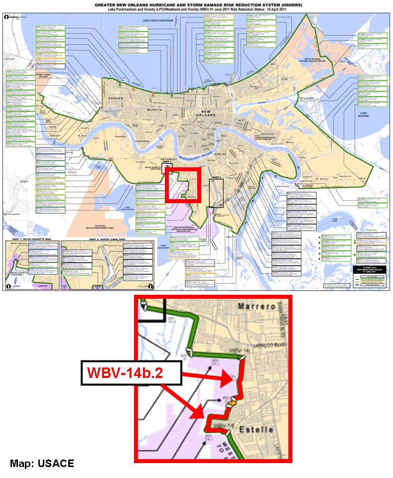
So where is Reach 16?
It's across the canal from Reach 30, down south of the I-10 bridges:

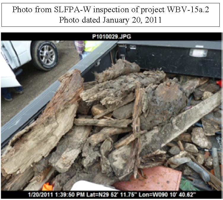
The Corps included pictures of it in the presentation:


Reach 16 was not included in the 17th Street canal remediation project when the contract was awarded in December, 2010. But now the Corps is saying extra dirt might be required at the toe of the levee (the part of the levee at its bottom where it goes from sloped to flat), and is even including pictures of the Reach 16 toe.
The changing Safe Water Elevation of Reach 16
So what's going on with Reach 16? The main chart of Safe Water Elevations on page 12 of the October, 2010 17th Street SWE report (report and all appendices here) shows the Safe Water Elevation for Reach 16 was the bare minimum of 8 feet, meaning no remediation was required:


So if the SWE was 8 feet, based on seepage considerations, what's the problem?
A clue comes from further inside the report. These types of reports are written from the inside out, with the individual results sections compiled first, and then the introductory and conclusory sections written around them. Those "outer" sections are the ones written last and which have the heaviest attention paid to them during editing, because they are the sections most likely to be read (who except crazies like me reads the whole report?).
So when one reads the introductory and conclusory sections, one finds this unambiguous statement reinforcing the main chart:
"Seepage was not found to be a concern on any reach of the 17th Street canal for an SWE below +8.0 feet."
But when we look at the individual section on the seepage results, we find this chart on page 124:


The actual calculations originally resulted in a seepage SWE of 7.5 feet, 6 inches below the 8 foot target. A SWE of 7.5 feet may have meant more remediation along the canal (theoretically, though we've seen the Corps ignore other sub-8-foot calculations). Reach 16 is 1615 feet long, so that's a lot of remediation.
So how did the SWE jump from an unacceptable value of 7.5 feet to the barely acceptable value of 8 feet? The report itself provides the rather bizarre answer, but first there's a brief detour to explain (in my rudimentary understanding) how seepage works.
The (very) basics of seepage
To help, here's a diagram of the layers of various soil along Reach 16:

This diagram is taken from the calculations for "slope stability," not seepage. The diagram for seepage doesn't include such clear delineations of the different soil types, so I grabbed this one.
As you can see, there's a thick layer of sand - shown in green - underlying the whole thing. I've noted that the bottom of the canal is at -9.4 feet, while the sand starts at -9 feet.
On the "protected" side - i.e. the non-canal side in Jefferson Parish - there's stronger, less permeable soil overlying this sand, both within the levee and next to it. That's the stuff shown in yellow and orange, labeled either "Marsh," "Embankment Fill," or simply "Fill." Below the sand is a layer of pretty impermeable clay, shown in red and brown. And at the top of the diagram is the I-wall, which penetrates down to -1.5 feet, or 7.5 feet short of the top of the sand layer and 44.5 feet short of the clay layer.
For seepage to occur, water from the canal must contact the sand surface directly. It must then travel through the sand to the protected side. For it to truly be a problem, though, it must exert an upward force against the protected-side soils which is greater than the force exerted downward by the weight of those soils. If it does this, then a connection like a pipe is made between the canal and the land side, and the foundation underneath the levee and floodwall can be quickly undermined.
In Reach 16's case, it would seem the first part of a potential seepage problem - a canal bottom lower than the top of the sand - is in place. The bottom of the canal is 0.4 feet into the sand layer. This condition is referred to by the Corps' consultants as an "open bottom," and Reach 16 is not the only reach along the 17th Street canal to exhibit it. Indeed, Black & Veatch analyzed five other reaches with survey data indicating an open bottom: 15 (later split into 15A and 15B), 31, 32, and 33. All these are reaches near the I-10 or Veterans bridges:

These calculations, while quite complicated in their guts, are simple in concept. The canal is modeled from known survey data. Water is placed in the canal up to the target SWE of +8 feet and to a maximum of +10 feet (the Corps limited SWE calculations to 10 feet of water, even though the walls are much higher). If the resultant calculated safety factor is above the prescribed safety factor for the particular type of failure under study (global stability, slope stability, gap, seepage, etc, each of which has its own safety factor), then the reach under consideration passes.
In the case of all those other "open bottom" reaches, Black & Veatch was able to load the canal up with water to an elevation of +10 feet and not fall below the Corps' seepage safety factor of 1.6.
But for Reach 16, Black & Veatch could only load the canal up with water to an elevation of +7.5 feet before they fell below the 1.6 safety factor. Just for reference's sake, the canal was able to be loaded up to +10 feet on Reach 16 for all the other types of failures Black & Veatch was looking at. So seepage was what is called the "controlling" criterion for Reach 16.
Sediment
Now, there's one other thing that can mitigate against seepage. That is stopping the canal water from getting to the sand in the first place. All three outfall canals have sediment along their bottoms, carried there from the city's streets and drainage tunnels and pipes. It is deposited there constantly, and especially when there's a rainstorm and water is pumped along the canals out to the lake.
I wrote about this sediment in 2009, when I based an entry on the 2007 iteration of the 17th Street SWE report. That report indicated sediment was quite thick along the entire canal. However, those thickness readings were based on soundings, not direct borings into the canal bottom. In addition, the 2007 report did not characterize the sediment at all, including its permeability or how much of it was mixed in with sand. The October, 2010 report notes (and this is quite important) that the Corps has still not measured the sediment, referred to as "fine grained materials:"
"[T]here are no borings in the canal to confirm the thickness of the fine grain materials over the beach deposits."
This is a yawning gap in the data required to completely analyze seepage.
As noted above, a number of reaches were analyzed as "open bottom" reaches. With regard to sediment, that likely means that Black & Veatch and the Corps made a judgement that the sediment blanket along those stretches was too thin to stop the water flowing through the direct connection exposed by the top of the sand layer being above the bottom of the canal. In addition, Black & Veatch also noted six other reaches - 14, 17, 18, 29, 30, and 34 - which had thin sediment layers, but whose canal bottoms were apparently not below the top of the sand layer. These weren't analyzed as open bottom reaches.
So they were making judgements about the thickness of the sediment layer throughout the preparation of the report. But how did they do so when they had no detailed canal borings to confirm those thicknesses? Where was the hard data?
Detailed borings of the sediment along the London Avenue canal bottom in 2010 led to a radical recasting of SWE calculations there, essentially restarting the engineering effort and eventually leading to the inclusion of many reaches in the remediation project along that canal which had previously been thought safe. Yet, no similar effort was undertaken along the 17th Street canal (or the Orleans Avenue canal for that matter).
So with no detailed information on the sediment overlying the beach sand at the bottom of the canal along Reach 16, and with a calculation showing a sub-8-foot SWE along that reach from seepage due to an open bottom, how then did the SWE jump 6 inches to 8 feet? What was that judgement based upon?
1983
This is where it gets bizarre.
Instead of either:
a) using the lack of detailed sediment data to take the conservative course - assuming an open bottom along Reach 16 and sticking with with the 7.5 foot SWE within the seepage section of the report, or
b) revealing the source of their heretofore undisclosed sediment thickness data,
Black & Veatch and the Corps chose a third course. They startlingly reached back almost 30 years to rebut their own seepage calculation. The report starts describing a December, 1983 test along the 17th Street canal's Reach 16 to determine whether a direct sand connection existed at the canal bottom. This test took place ahead of 1984-85 dredging of the canal by the Sewerage & Water Board, before the later walls were designed and built. The test was used to help get a permit from the Corps for that dredging. Presumably, reassuring the Corps that the canal would not be undermined by seepage during the dredging would go a long way toward getting the dredging permit. Since the dredging happened, it clearly did the trick.
In fact, seven years later, as part of the now-discredited 1990 17th Street canal design document which led to the placement of the I-walls destined to fail in 2005, the Corps themselves used the report of this test in the same way: to rebut concerns about seepage. Thus, it is beyond surprising to see it resurrected here to do the same thing a third time - rebut concerns about seepage - as if nothing had happened in the intervening decades.
Nonetheless, two whole pages of the 2010 report are devoted to blithely describing the 1983 test, recommended by Eustis Engineering to the then-consulting engineers on the dredging, Modjeski & Masters (Eustis still does millions of dollars of geotechnical work for the New Orleans District). The complete report on the 1983 test can be found within volume 2 of the 1990 Design Memorandum 20 (or DM-20), the base design document for the 17th Street canal walls. Scroll to page 78.
In 1983, at Eustis' recommendation, a 100' by 100' square area in the middle of the canal was excavated to expose the beach sand. Also, at Eustis' recommendation, piezometers were installed on the land side of the Reach 16 levee, just south of I-10. These piezometers sensed the water elevation in the soil below. If there were a seepage connection between the water in the canal and the piezometers outside the canal, changes in the canal water elevation would be reflected in the piezometer readings. Similar arrangements were a part of the 2007 London Avenue canal load test.
According to the 2010 report, during the 1983 test the water in the canal went up 0.41 feet while the sand was exposed on December 16, 1983, but the piezometers outside the canal either went down or remained unchanged. The 1983 test authors also noted that the test location was partially covered in sediment on the 16th, and that the entire location was covered in sediment three days later. To Eustis, this demonstrated that there was no seepage connection, either from the sediment cover or because there just wasn't one. Frankly, their reasoning is quite muddled.
However, Black & Veatch accepted the "no seepage" finding of the 1983 test, while including a token suggestion that before the SWE for Reach 16 is finalized, "a sampling program be performed to determine whether a [sediment] blanket exists at this location." But nowhere in the 2010 report does it indicate such a sampling program took place before the SWE for Reach 16 was raised to 8 feet in that same report. Indeed, there was no such sampling program during the 1983 test either. It appears that the 8 foot number came about directly - and only - as a result of Black & Veatch and the Corps accepting the findings of the 1983 test as gospel. It's like they just willed it into being. This is supported by the footnote on the master SWE chart on page 12 of the report:
...as well as the plain text of the 8 foot SWE in the main chart itself. This was stunning for me to read - a consultant in 2010, using the Corps' incomplete, muddled pre-Katrina design data to support a conclusion not supported by the post-Katrina data record, a data record also lacking key pieces of information. It's almost like they were looking for any shred of evidence that might support their pre-made conclusion that seepage could not possibly be a problem, their own calculations be damned.
I was not the only one to notice this.
Behind the scenes
On a consultant-written report such as this one, after the report is drafted it is sent to lots of people outside and inside the Corps for comments. They use a system called "Dr Checks" to log those comments, the responses, and the responses to the responses. Thus, the Dr Checks printout is the sort of document the public almost never sees - the official record of the internal engineering debates that go into the formation of these reports.
When I got the October, 2010 17th Street and Orleans Avenue reports, I was stunned to find the Dr Checks printouts were included as appendices (the London Avenue report didn't have one). The Orleans Avenue one runs 159 pages (complete Orleans Avenue report and appendices here). The 17th Street one is significantly shorter - just 25 pages long.
That doesn't mean the 17th Street Dr Checks printout is any less valuable. In fact it contains a brief but vigorous debate over seepage along Reach 16.
Keep in mind the Dr Checks comments are based upon draft versions of the report which we don't have. Thus, sometimes the comments mention a criticism which - when one reads the final report - it is clear eventually got addressed. Nonetheless, this particular chain of comments is extremely enlightening.
The comment chain starts with Noah Vroman, a Corps seepage expert working at the Corps' Engineer Research & Development Center (ERDC) in Vicksburg, Mississippi. Vroman's name has popped up often in the past few years in the many reports generated on seepage concerns along the London Avenue canal.
On July 23, 2010, Vroman says of Reach 16,
"I calculated a FOS [Factor of Safety] of 1.2 at a WL [Water Level] of 10.0"
He is noting this because the acceptable seepage safety factor is 1.6.
Black & Veatch geotechnical engineer John Koontz is the first to reply to Vroman, on August 7th:
"This reach was reviewed. A full scale canal seepage test was performed by excavating the beach deposits. No response was observed at the toe. The report is in DM-20 Vol. II. Discussion of this test has been added to the report."
As noted earlier, the "toe" is the section of the levee at the bottom, where it goes from sloped to flat. It is generally the most vulnerable section, because there's less soil there than at the top.
Also as noted above, "DM-20" is the 17th Street Design Memorandum, or the official design document underpinning the floodwalls and levees which failed in 2005.
As to the substance of Koontz's comment, we can surmise that the description of the 1983 test had not been included in the draft version Vroman was reviewing in July.
Vroman responded on September 23rd with one of the longest Dr Checks comments I've seen in these documents. From the date and the context of the comment, I surmise this September 23rd comment is based upon a subsequent draft, which we don't have. Note that I've added paragraph breaks to Vroman's comment to make it more readable:
"Do not agree with response.
I believe key elements of the results of the test section are not adequately addressed in the revised SWE report. The test section that is reference[d] was conducted in 1983 due [to] concerns with dredging operations in the canal that could potentially expose beach deposits in the canal. Eustis Engineering Company provided expertise and guidance for the test. They concluded from the test that "the possibility of blow out during high-water conditions in the canal is probably slight" and additional monitoring during dredging operations should be conducted. It is obvious that Eustis Engineering was concerned after the test that a "blow out" condition could still occur."
Let me pause here and point out that additional monitoring was conducted during that dredging. Piezometers were installed outside the canal as the dredging advanced along the canal between December, 1984 and April, 1985. They didn't really show any evidence of seepage. However, there was no characterization of the canal bottom as part of that monitoring.
Returning to Vroman's comment:
"The key elements that should be included in the SWE report concerning seepage and the canal test are:
- This was not a full canal test but merely monitoring an area where the possibly [sic] of exposing the beach sand was likely.
- after excavation of the test section, a boring was taken just three days later and there was 2.7 ft to 4 ft of sedimentation above the sand. The authors of the test section report indicated that this sediment was the likely reason the piezometers did not respond to changes in canal water elevations.
In addition, the authors of the test section report also indicated that the beach sand at the bottom of the canal was possibly contaminated or mixed with fines and "sealed" the bottom of the canal."
Based on the final text of the 2010 report, it appears this information was not in the September draft, but was included in the final report as a result of this comment.
Vroman continues:
"Thus it is important for the SWE evaluation analysis to consider whether this sedimentation layer exists within this reach. The same diligence used on the London Avenue SWE report for seepage concerns and sedimentation in the canal should be used in this reach.
Regarding this SWE report and the condition of the canal in 2010 and beyond, does a reliable sedimentation layer exist above the beach sand that will prevent adverse seepage conditions?"
And there it is - the critical question. Essentially, "what hard data do we have on the sediment?" And he's not asking for what was known in 1983 about a 100' by 100' section, but what is known along the entire canal - today. As was demonstrated on the London Avenue SWE effort, complete characterization of the sediment is unbelievably critical to understanding seepage. Since there has not been any comprehensive effort to do so along the 17th Street canal, it is only conservative to stick with the results from the "open bottom" calculations, which gave the 7.5 foot SWE for Reach 16. And, more importantly, the lack of that current, comprehensive sediment data brings into question how correct the seepage calculations are for the entire canal.
Vroman didn't just bring this up on the 17th Street report. We find him asking the same questions about sediment (also called "silt") on the Orleans Avenue report, because - like along the 17th Street canal - there was no comprehensive characterization of canal sediment at Orleans either. From a comment on the Orleans Avenue Dr Checks printout marked "this item flagged as a critical issue:"
"Different approach was used in Orleans canal as opposed to London.
For the London analysis, silt layer in the canal was critical feature for seepage and was deemed nonexistent if silt is less than 2 feet thick. For Orleans no canal side investigation was performed to determine the thickness of any impervious layers above the sand. This aspect is very critical to the analyses.
For Reach 1, there is only about 1.6 feet of marsh shown above the sand. This assumption was made purely on survey data and assuming the [base of the] marsh is constant between borings 200 feet apart (east bank and west bank). I think using this approach would warrant more conservatism than used for London. Anything less than 3 feet thick should be assumed to be nonexistent and direct connection to the bottom of the canal could be possible."
Vroman's comments on the Orleans Avenue report appear to have won the day, as his concerns about seepage led to the seepage calculations getting redone to include consideration of an "open bottom" on Reach 1 and other places. And on Reach 1, seepage was found to be to be the controlling criterion. In fact, sheet pile is being driven there to completely cut off the seepage path as part of the Orleans Avenue remediation project, as shown in this photo from the June update:

Of course, without a comprehensive characterization of the sediment along the Orleans Avenue canal, doubt remains about many of the other seepage calculations.
The outcome on the 17th Street canal report was quite different. The Black & Veatch SWE project manager, Larry Almaleh, responded to Vroman's 17th Street comment on October 1, 2010, just before - or perhaps the day of - the report's final issuance:
"The SWE for a FOS of 1.6 for an open bottom condition at this location as identified in the report is elevation +7.5 [feet]. Based on the identification of a significant sedimentation at the base of the canal and the lack of response in the piezometers raising of the SWE to +8 is not unreasonable. Note in multiple meetings and corresondence B&V has been told there is no seepage concerns in the 17th street canal by the HPO and the external review group."
Nowhere in the report is a precise identification of "significant sedimentation" outside of the 1983 test actually named or described.
But most telling is that the Corps ("HPO" is the Corps' Hurricane Protection Office, co-located with the New Orleans District) had apparently told Black & Veatch the result of the seepage calculations before they were done: "B&V has been told there is no seepage concerns in the 17th street canal by the HPO..."
I thought Black & Veatch was supposed to be reporting to the Corps on seepage concerns, not the other way around?
Handwaiving
So stepping back from all this, it looks to me like there was a ton of handwaiving going on around the seepage concerns at the 17th Street canal's Reach 16 specifically, and along the entire 17th Street canal generally, possibly on orders from the Corps Hurricane Protection Office in New Orleans. And while Vroman's comments apparently got an expanded description of the 1983 test added to the final report, it didn't change the underlying fact that Black & Veatch and the Corps were solely relying on a nearly 30-year-old test from a discredited document to support their pre-reached conclusion that seepage was nothing to worry about along the 17th Street canal.
So not surprisingly, despite calculations and the Corps' own non-New Orleans-based experts pointing to the absolute need to fully characterize the depth and composition of the sediment along the canal bottom, not to mention possibly remediate the 1615 feet of Reach 16 because of seepage, Black & Veatch issued their report in October, 2010 with the conclusive statement,
"Seepage was not found to be a concern on any reach of the 17th Street canal for an SWE below +8.0 feet."
That conclusion then flowed directly into the scope of the remediation project along the 17th Street canal. Until this most recent project update nine months after the SWE report was issued and seven months after the remediation contract was signed, there has been no effort to address seepage along the canal, including at Reach 16. All the remediation efforts are geared to other concerns like overall stability.
The way the Corps and Black & Veatch got to that outcome - even if they are possibly correcting it now - should make people very queasy. How could anyone in good conscience use nearly 30-year-old incomplete 17th Street design data and ignore post-Katrina data collection and calculations to support conclusions about the canal's safety in the present day? After all that has transpired, and after all the Corps' pronouncements that they've changed, it looks like more of the same over five years later.
Reach 16 to be fixed anyway?
That brings us full circle to the June remediation project update, which mentions that the Corps is now looking at putting 6 to 18 inches of dirt at the toe of the levee along Reach 16, based on surveys of the reach. That toe is undoubtedly the point found vulnerable in the Black & Veatch seepage calculation that found the 7.5 foot SWE. Thus, if more soil is piled over it, presumably water carried through the sand by seepage would not be able to push up and cause a failure.
Of course, the only definitive solution to stopping seepage is not piling more dirt on the landside, but driving of 60 foot steel sheet piling into the clay layer along the entire reach. In fact, that has been how seepage has been controlled everywhere else, including on both the Orleans Avenue and London Avenue remediation projects. I assume the Corps thinks that's too expensive or time-consuming or embarassing to do so along the 17th Street canal, so they are proposing a band-aid of a slightly thicker levee toe. It's a half-measure that doesn't fully address the problem.
The June update does not make clear whether the survey is of the canal bottom or the levee. We can hope it is of the canal bottom. Perhaps this is the "sampling program" given a token mention in the 2010 report? Indeed, we can hope there is a comprehensive effort underway to characterize the sedimentation along the canal bottom, and that effort will lead to a recasting of the engineering similar to what happened along the London Avenue canal last year. Since this update is about a month old, we should know whether those hopes are just that within a couple of weeks.
posted by mcbrid35 at
11:00 AM
|
0 comments
![]()
![]()


